Aug 7 2019
Beauce Gold Fields, a gold exploration company, has announced the results of a geoelectric tomography survey performed in the western part of the Beauce Gold property.
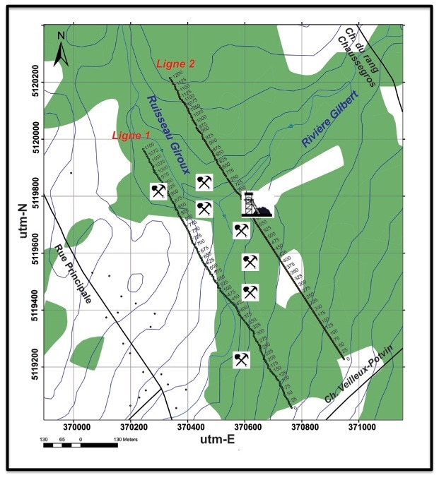
 Location map of lines 1 and 2 of the geoelectric tomography survey. (Image credit: Beauce Gold Fields)
The Beauce Gold property is in the town of St-Simon-Les-Mine, situated in the Beauce region in southern Quebec.
The presence of a structural discontinuity was indicated by the two-dimensional (2D) inversion models of induced polarization (IP) and electrical resistivity. This structural discontinuity was inferred as the southwesterly extension of the main fault identified by geophysical surveys conducted in 2017 and 2018.
The structure, which is locally linked with IP anomalies, is situated underneath former (placer) gold production shafts and close to the discovery locations of the largest gold nuggets present in the Gilbert River valley.
The presence of disseminated sulfides in volcaniclastic rocks was indicated by IP anomalies. These sulfides suggest that the bedrock may host gold mineralization.
The results of the geoelectrical tomography survey is another solid piece of evidence that narrows our exploration efforts to find the bedrock source of the gold-bearing placers of Saint-Simon-les-Mines.
Patrick Levasseur, President and CEO, Beauce Gold Fields
Mr Levasseur added, “our rock outcrop sampling program is currently underway and is proceeding exceedingly well. We should be able to provide an updated shortly.”
The above map shows the location of the two lines of the geoelectric tomography survey. Both the lines are situated in a wooded region, crossing the Gilbert River before (line 2) and after joining the Giroux Creek (line 1).
The lines were established on the basis of the gold prospects of the area as demonstrated by the massive number of gold-bearing shafts and also the discovery areas of the largest historical gold nuggets found in Canada.
The geoelectric tomography survey revealed the presence of clear lithological blocks situated on either side of the Gilbert River. The rocks are systematically more resistive on the north side of the river.
Such an observation suggests that contact may exist between sedimentary rock units located in the south (St-Victor Formation), showing comparatively few IP anomalies as well as volcaniclastic dominant units (Beauceville Formation) located in the north of the Gilbert River. The latter is defined by robust anomalies of electrical chargeability.
As seen in the field, brittle deformation, which is usually linked with the injection of carbonates and quartz veins, influences the volcaniclastic dominant units. On the contrary, these structures were observed to be infrequent in the shale-rich units of the St-Victor Formation.
The gravity and magnetic contrasts seen in this sector further indicate the faulted contact between the Beauceville Formation and the St-Victor Formation. A simple synclinal structure cannot explain these contrasts of physical characteristics of the rock units.
Consequently, a fault is not likely to be the present in the Gilbert River area. It must be noted that Line 2 travels close to ancient gold mining wells of the 19th and 20th century. Some part of these can still be seen in the anomaly area situated below the 600 m-station.
An exploration program involving sampling, prospecting, and channeling outcrops of the Beauceville Formation in the north section of the Gilbert River is presently ongoing.
The two lines of the geoelectric tomography survey were part of a significant geological and geophysical work performed in 2017 and 2018 on numerous sections of the property located between the Municipalities of St-Benjamin and St-Simon-les-Mines.
This indicates the potential presence of a massive fault that stretches more than 4.5 km and is aligned with the previous placer gold mines (the report is titled “Report Of Gravimetric Surveys and Geoelectric Tomography of 2018,” written by Professor Marc Richer-LaFlèche of INRS).