Aug 7 2019
Origin Gold Corporation reports new results of the surface exploration on its gold mining concession, La Pantera (the “property”).
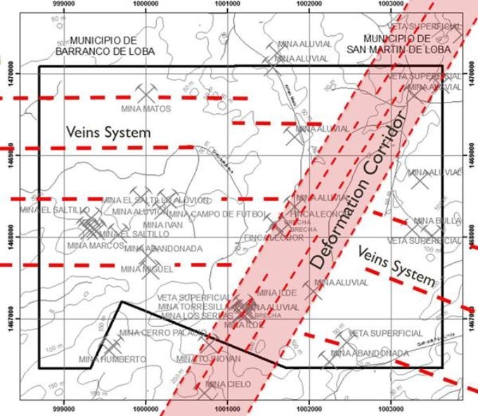
 Main Deformation Corridor. (Image credit: Origin Gold Corporation)
Origin continued its surface exploration program on the property that encompasses an area of 1,734 hectares in the gold-rich San Lucas Range, department of Bolivar, in Colombia. The program is consistent with the recommendation of the National Instrument 43-101 technical report dated August 20th, 2018, prepared by Pierre O’Dowd.
Regional Geology
Origin’s technical team has recently finished the regional geology over the total property with over 100 km of traverses, which resulted in the reinterpretation of the structural pattern that controls the mineralization.
Main Deformation Corridor
A large deformation corridor striking SW/NE has been detected cutting diagonally across the property. This large fault/shear zone, sometimes observed over a width of 200 m, was followed inside the concession for over 4.5 km. The results of the magnetic (“MAG”) survey establish the position and the extension of this mineralized trend inside the property.
Moreover, geomorphological observations, trenches, outcrops mapping, and active artisanal mining sites show the continuity of this deformation passage up to 2.5 km northeast of the property.
The large fault/shear zone allowed the emplacement of a standard hydrothermal system characterized by strong silicification, veinlets, and quartz veins as well as hydrothermal breccia zones displaying anomalous gold values, even in highly gold-depleted meteorized superficial rock occurrences.
The presence of gold is further established by broad active saprolite exploitations and several small underground mining operations all over this SW/NE trend. It is assumed that this large shear zone cuts via older gold bearing veins and has probably generated secondary extensional faults allowing the emplacement of gold-rich veins systems, during different hydrothermal events, striking E-W on the west side and striking NW/SE on the east side of the deformation zone.
East-West veins system
To the west of the large deformation corridor, a strong E-W striking veins system has been noticed. This veins system is made up of many parallel veins that spread from south to north (Mina Matos) in the property and is associated with the presence of iron cap oxides at an elevation of more than 100 m. The veins are vertical to sub-vertical and range from 0.10 to 0.50 m in thickness. They are made up of huge quartz with sphalerite, pyrite, and galena with substantial gold values.
In the southwestern portion of the concession, the geological team discovered fragments of botryoidal and nodular iron oxides. The origin of those iron oxide crust blocks was situated on top of hills where an iron laterite cap was identified.
Northwest-Southeast veins system
The geological survey carried out in the southeast portion of the property, exposed the existence of an intense system of parallel veins striking NW/SE spreading 2 km from Mina Bulla to Los Pueblos at the southern limit of the concession. To better establish this vein system, 11 trenches were dug and sampled in this extremely meteorized zone. The finest gold assay results came from the first discovery, an open cut face, with an average of 0.8 g/ton Au over 13 m from saprolite and many quartz veins and veinlets.
Results from the sampling of these trenches are believed to be exciting, considering that the meteorization process typically depletes the gold content near the surface. They also reveal that the vein system is open to north, towards Mina Bulla veins.
Technical surveys
The MAG and the drone surveys are on-going, and are projected to be completed by the end of October 2019.
Additionally, the geological team has begun visiting, mapping, and sampling all the active underground artisanal mines totaling over 20 at the moment.
Quality Assurance/Quality Control
All samples were shipped to Actlabs in Medellin and were assayed for gold using the following techniques:
- Code 1A2 Au - Fire Assay AA
- Code 1A3 Au - Fire Assay Gravimetric (QOP AA-Au)
The samples were properly located (GPS), gathered, bagged, numbered (paper tag inside each bag and plastic bag numbered with a marker), described, and sealed on site under the direction of the geologist. They were sent by truck to Medellin to an accredited laboratory (Actlabs in Medellin, Colombia, ISO9001:2015) following proven chain-of-custody protocols.
Qualified Person
This press release has been reviewed and approved by Daniel Goffaux, P.Eng., a Qualified Person as stipulated by National Instrument 43-101. Mr. Goffaux is not independent of the Corporation as he acts as chief technical advisor for the Corporation.