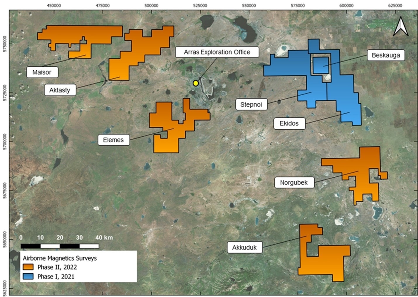
The successful conclusion of a 92,400 line-kilometer high-resolution aerial magnetics study has been announced by Arras Minerals Corp. The company now has continuous airborne magnetic data spanning the entire area of its exploration licenses in northeastern Kazakhstan, which is 3,028 km2.
 Airborne magnetics surveys covering Arras’ mineral exploration licenses in northeastern Kazakhstan. The earlier 21,000 line-kilometer Phase I survey (blue) covered the Beskauga, Stepnoe and Ekidos licenses, and the 71,400 line-kilometer Phase II survey announced here (orange) covered the Maisor, Aktasty, Elemes, Norgubek, and Akkuduk licenses. Also shown is the location of Arras’ exploration office in the city of Ekibastuz. Image Credit: Arras Minerals Corp.
Highlights
- A 92,400 line-kilometer high-resolution airborne magnetics survey at a regional scale has been finished.
- The 3D inversion over chosen areas and post-survey processing of the survey data have been finished. Arras Minerals now have the complete data products.
- Multiple prospects for porphyry, epithermal, VHMS (volcanic-hosted massive sulfide), and orogenic gold mineralization have been discovered through preliminary interpretation. A thorough structural interpretation is still in process.
Tim Barry, the Chief Executive Officer and Director for Arras Minerals Corp. stated, '" This is one of the largest airborne geophysical surveys flown in Kazakhstan in recent years."
Despite being positioned in a productive copper-gold belt, the survey represents the first time that many of our exploration license areas have been flown by geophysics in over 60 years. Acquisition of the new airborne magnetics dataset is a major first step in understanding the geology and mineral potential of our licenses, many of which are covered by 20—40 m of unconsolidated overburden.
Tim Barry, Chief Executive Officer and Director, Arras Minerals Corp.
Barry added, “3D inversion and initial analysis of the resulting data have already yielded several compelling targets, especially for porphyry and epithermal mineralization that will be investigated by our field crews this summer. An exciting pipeline of new copper-gold prospects is sure to develop as a result of this survey.”
Airborne Magnetic Survey Summary
One of the top geophysical service providers in the Republic of Kazakhstan, “SPC GEOKEN LLP,” acquired data between Q4-2021 and Q1-2022. The company’s exploration licenses for Maisor, Aktasty, Elemes, Norgubek, and Akkuduk are covered by the 71,400 line-kilometer high-resolution aerial magnetics survey.
The same contractor did a 21,000 line-kilometer aerial magnetic survey over the company’s Beskauga, Stepnoe, and Ekidos exploration licenses in H12021. The new survey expands on that work. The area’s contiguous magnetic survey data now covers over 3,028 km2 in Arras.
Two Antonov An-2 aircraft flew the survey in an east-westerly direction at a ground clearance of 70 m, with a line spacing of 100 m and tie-lines of 1,000 m. Francis Moul P.Geo, a Principal Geophysicist with Condor North Consulting, ULC, in Vancouver, independently oversaw quality control throughout the entire survey period.
Additionally, the survey data post-survey processing and 3D inversion across a few selected locations were contracted out to Condor. The management is currently doing a thorough review to improve exploration objectives after receiving the final data outputs.