Doré Copper Mining Corp. (the "Corporation" or "Doré Copper") is delighted to declare its plans to drill multiple high-priority copper-gold targets in the Central Chibougamau mining camp, situated close to its prevailing Copper Rand mill, adjacent to Chibougamau, Québec. At the end of June, the drilling program is planned to begin.
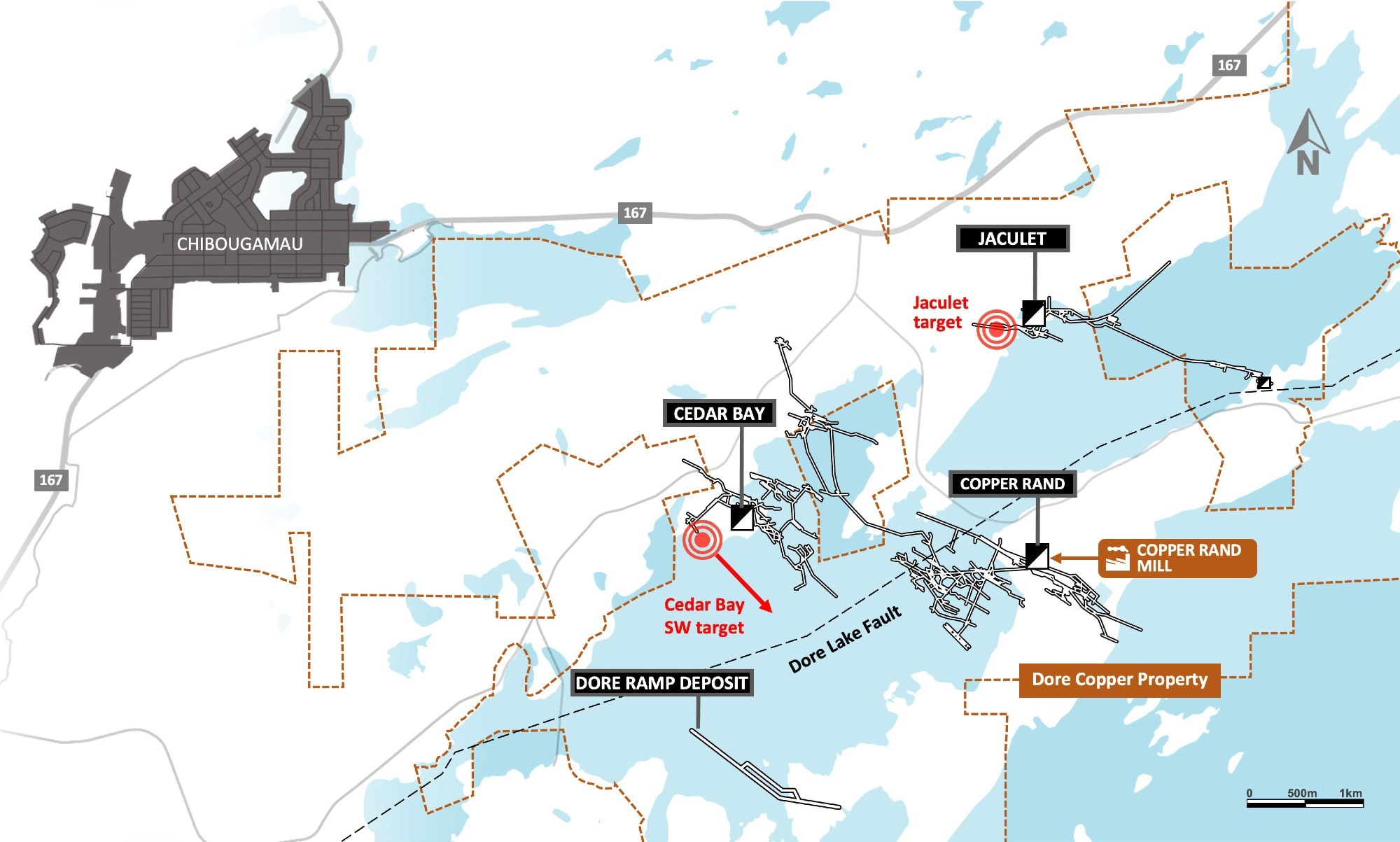
 Plan View of Copper Rand Property Showing the Jaculet and Cedar Bay SW Targets. Image Credit: Doré Copper Mining Corp
High Priority Drilling Targets:
Jaculet
Situated 2.5 km by road from the Copper Rand mill, the Jaculet mine was functioning between 1960 and 1971 and generated a sum of 1,091,000 tons at 1.84% Cu, 1.44 g/t Au, and 6.85 g/t Ag (20,074 tons of Cu and 1.57 tons Au). In 1972, Jaculet was mined to a depth of 366 m (1,200 feet) and the shaft was deepened to 500 m (1,650 feet).
The Jaculet mineralized system comprises two separate shear zones, called Zone 1 and Zone 2, which stay open at depth with very slight progress less than 366 m.
At a vertical depth of around 400 m, Zone 1 was intersected by two surface holes finished in 1956 by Chibougamau Jaculet Mines Ltd. Hole V17 and V17A (wedge from V17, situated nearly 50 m to the east) intersected 4.55% Cu and 0.86 g/t Au over 6.7 m and 4.25% Cu and 0.59 g/t Au over 6.4 m, respectively.
Two holes are planned to be drilled by Doré Copper for a sum of 1,300 m. In Zone 1, the first hole will assess the potential down plunge extension of holes V17 and V17A. Another potential ore shoot will be assessed by the second hole. This ore shoot is situated around 400 m to the west.
The Jaculet deposit is characterized by two separate subparallel shear zones, called Zone 1 and Zone 2, divided by around 200 m, where the veins inside both zones normally range between 91 and 137 m in strike length. Zone 1 spreads for around 500 m and has an average strike of 290° with a northerly dip ranging between 55° and near vertical.
In Zone 1, mineralization comprises minor pyrite and chalcopyrite inside the sheared and altered gabbroic anorthosite. Zone 2 is oriented at 80° north dipping 80-85° to the south and spreads for around 670 m in length. Mineralization comprises stringers of pyrite with erratic lenses of chalcopyrite related to sericite, chloritoid, and siderite.
Cedar Bay Southwest Zone Extension
Situated 300 m southwest of the Cedar Bay Main Zone, Southwest Zone was partly developed by Campbell Chibougamau Mines Limited to a maximum of 200-m (650-feet) level, right at the property limit with Patino Mining. The prospective extension of the Cedar Bay Southwest Zone along strike to the southeast was not assessed ever before by Patino Mining and resulting companies that regulated that ground. Altogether, around 800 m of strike length has not been assessed up to the Lac Doré Fault.
From the same pad, Doré Copper thinks of drilling two holes for a sum of 1,500 m to assess the possible southeast extension of the Cedar Bay Southwest Zone.
The Cedar Bay mine functioned between 1958 and 1990 and generated 3.9 million tonnes grading 1.56% Cu and 3.22 g/t Au. The ore was processed from the mine at the Copper Rand mill situated 5 km by road. The deposit was mined to 670.5 m deep and the prevailing shaft spreads to 1,036 m deep.
Doré Copper, while private, finished four holes (along with wedges) that include 4,842 m in 2018 and reported an Indicated resource of 130,000 tonnes at 9.44 g/t Au and 1.55% Cu, and an Inferred resource of 230,000 tonnes at 8.32 g/t Au and 2.13% Cu (effective date of December 31, 2018). In 2020, the Corporation finished 9,025 m of drilling and efficiently extended numerous mineralized lenses (the 10-20A and 10-20B).