Medaro Mining Corp, a Canada-based lithium exploration company, declared the successful culmination of its diamond drilling program at the CYR South Lithium Property, situated in the eminent landscapes of James Bay, Quebec, Canada.

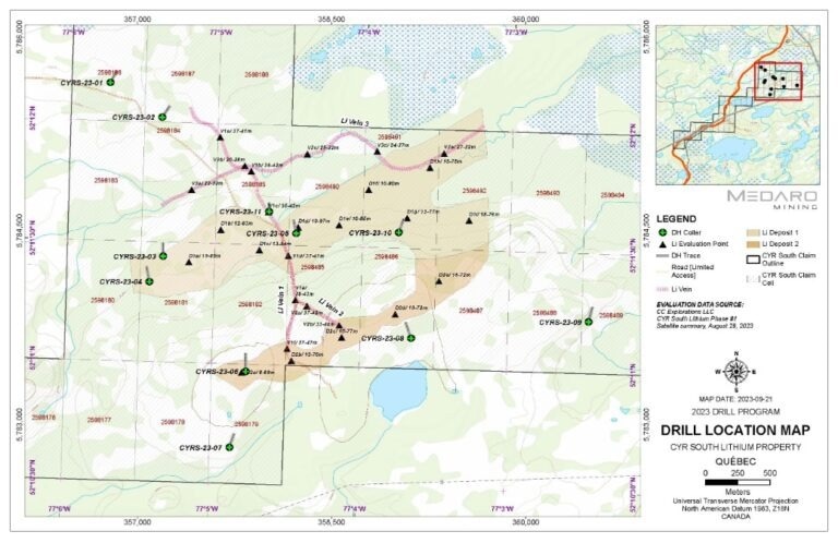
Drill Hole Location Map. Image Credit: Medaro Mining Corp.
This milestone signifies a significant step forward in the ongoing exploration efforts in this highly promising area.
Over the past month, the company partnered with Forage Pelletier Drilling of Chapais, Quebec, to execute a meticulously planned drilling initiative (Program). This comprehensive program encompassed a total of eleven NQ size drill holes, spanning a distance of 1,745 meters (m) of NQ size diamond drilling.
The selection of drill hole locations was based on comprehensive groundwork carried out in 2022, during which several pegmatites with different widths and lithologies were identified. These pegmatites played a crucial role in determining the placement of drill holes. The preliminary logging data from the drill holes has confirmed the presence of subsurface pegmatites, with widths ranging from 1 to 95 meters, indicating their continuation from the surface.
To maximize the likelihood of success in this exploratory endeavor, four of these drill holes were strategically located either directly on or in close proximity to the Satellite Imaging Targets (SIT). This data-driven strategy underscores our dedication to improving the efficiency and efficacy of our exploration efforts.
Medaro Mining remains unwavering in its commitment to unlocking the exploration potential of the CYR South Lithium Property. The company eagerly looks forward to the analysis of the data and discoveries resulting from this diamond drilling program as it propels closer to achieving the vision of sustainable resource development in the James Bay region.
The successful completion of the diamond drilling program at the CYR South Property signifies a pivotal moment in our ongoing quest for sustainable resource exploration.
Michael Mulberry, Medaro Mining Corp
Mulberry added, “Our partnership with Forage Pelletier Drilling has played a pivotal role in achieving this milestone, and we take immense pride in the dedication and determination of our exceptional team.
“The presence of significant pegmatite formations and our strategic drill hole placements near the Satellite Imaging Targets are encouraging indicators of the property’s potential. We remain steadfast in our commitment to responsible exploration and look forward to advancing our understanding of the CYR South Lithium Property,” continued Mulberry.
About Core Logging and Sampling
Stringent quality control and quality assurance (QA/QC) protocols have been scrupulously integrated into every stage of the exploration process. Forage Pelletier has established a temporary core storage facility and conducted initial logging of the drill core at Camp 381, which serves as the operational base for the current drilling program.
Following this initial logging, all drill core samples are transported to a dedicated core shack situated in St-Dominique du Rosaire village, located approximately 400 kilometers south of the Property, for comprehensive logging. Field duplicates, standards, and blanks are consistently introduced at industry-standard intervals to ensure the precision and reliability of the obtained results.
The gathered samples are meticulously packed and sent to Activation Laboratories (“ACTLABS”) in Ancaster, Ontario, an independent laboratory certified to ISO standards, for analysis using laboratory code Ultratrace 7 and sodium peroxide fusion (Na2O2).
About Satellite Imaging Technology (SIT)
The Company enlisted the services of CC Explorations LLC from the USA, facilitated by their agent, Geosaterra Technology Corp. based in Langley, British Columbia, to conduct an initial Satellite Assessment of a portion of the CYR Lithium Property. CC Exploration presented compelling arguments to support the effectiveness of its technology in identifying lithium exploration targets at greater depths.
- With nearly 80 years of history, satellite technology continually evolves with new applications. It empowers the examination of molecular structures and provides measurable frequencies for various elements, including metals, oil, gas, water, and more.
- NMR technology, harnessed via satellites for over a decade, captures neutron measurements, which can be extrapolated to determine various elements and subsurface formations, serving as a swift reconnaissance tool.
- In practical operations, CC Exploration conducts satellite imaging to confirm the presence of the target element, subsequently offering GPS coordinates for ground sensors.
- Frequency density data is collected onto SD cards over a 30-day period and then processed for 3-D modeling.
- Additionally, Medaro announced the successful completion of their initial work program at the Pontax project, which is 100% owned and comprises 101 claim units. These claims are located 36 km southeast of the CYR South project.
The program encompassed comprehensive property mapping, identifying all visible Pegmatite outcroppings. Samples from these outcrops were collected and sent to the laboratory for analysis.