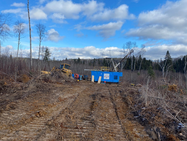
A drill program has been initiated on the Marriott Gold Property in Matheson, Ontario, according to a statement released by Plato Gold Corp. Drilling on exploration targets based on promising geology and geophysics will comprise 450 meters and two drill holes. The drill program is a follow-up to Plato’s airborne magnetic survey in the spring of 2022 utilizing an Unmanned Aerial Vehicle (UAV). The drill holes are 11 kilometers east of Agnico Eagle's Holt gold mine complex.

Drill set up on the first drill hole on Marriott Property. Image Credit: Plato Gold Corp.
Marriott Property Highlights
- The gold mining camp Abitibi Greenstone Belt is located within the Abitibi Greenstone Belt
- Located on Highway 101, offering excellent access
- Situated 45 km northeast of Kirkland Lake and 130 km east of Timmins, this location boasts excellent infrastructure
The suggested drill holes were chosen in accordance with the Abitibi gold deposits’ geophysical and geology features.
- Anomalies in gravity, electromagnetic (EM), and magnetic fields
- Porcupine-Destor Deformation Zone parallel to the deformation zone
- NE-SW trending fault
- The historic Harker and Iris gold mines are located in the same stratigraphic unit
Geophysics anomalies were used to determine the drill hole collar locations. Magnetic high, electromagnetic (EM) high, and gravity high are all correlated with the drill hole collars. The iron-rich tholeiitic basalts lithology unit is associated with the total magnetic intensity high.
Mineralization of gold and sulfides can also be related to electromagnetic and magnetic abnormalities. The historical Harker and Iris gold mines, as well as the planned drill holes, share the same regional gravity high characteristic.
Plato is pleased to commence drilling on one of our well-located gold properties in the Harker/Holloway gold camp. All of our properties have excellent infrastructure nearby, as well as either currently operating or historic mining operations.
Anthony Cohen, President and Chief Executive Officer, Plato Gold Corp.
The Marriott Property is situated in the well-known gold mining camp in the Abitibi Greenstone Belt. The drill hole locations’ geology is situated in a southern deformation zone that runs parallel to the Porcupine-Destor Deformation Zone on the property’s northern border.
The initial vertical derivative of the 2022 UAV drone magnetic survey revealed NE-SW trending crosscut faults close to the intended holes. These flaws could act as conduits for fluids containing gold. Gold mineralization in the Abitibi Greenstone Belt is typically linked to the Porcupine-Destor Fault, splay faults, and crosscut faults.
The proposed holes are on a southwest-trending stratigraphic unit that extends to the Howey-Cochenour-Williams occurrence (Au, Cu, Pb, Zn), the Harker gold mine (Au, Ag), and the Iris mine (Au, W). This is indicated by the regional geophysics second derivative magnetic high. The proposed drill holes are situated 14.7 km southwest of the Harker gold mine.
In 1986–1988, New Strategic Metals, in partnership with Silverhawk Resources Ltd., finished underground exploration in the Harker Gold Mine's No. 1 shaft region by driving a ramp down to a 500 ft level. 10,500 tons at 0.051 oz Au/ton and 6,000 tons at 0.115 oz Au/ton were stockpiled as a consequence of underground exploration and subsequently processed at the Holt-McDermont Mine Mill (Ontario Mineral Inventory, MDI 32D05NW00159).