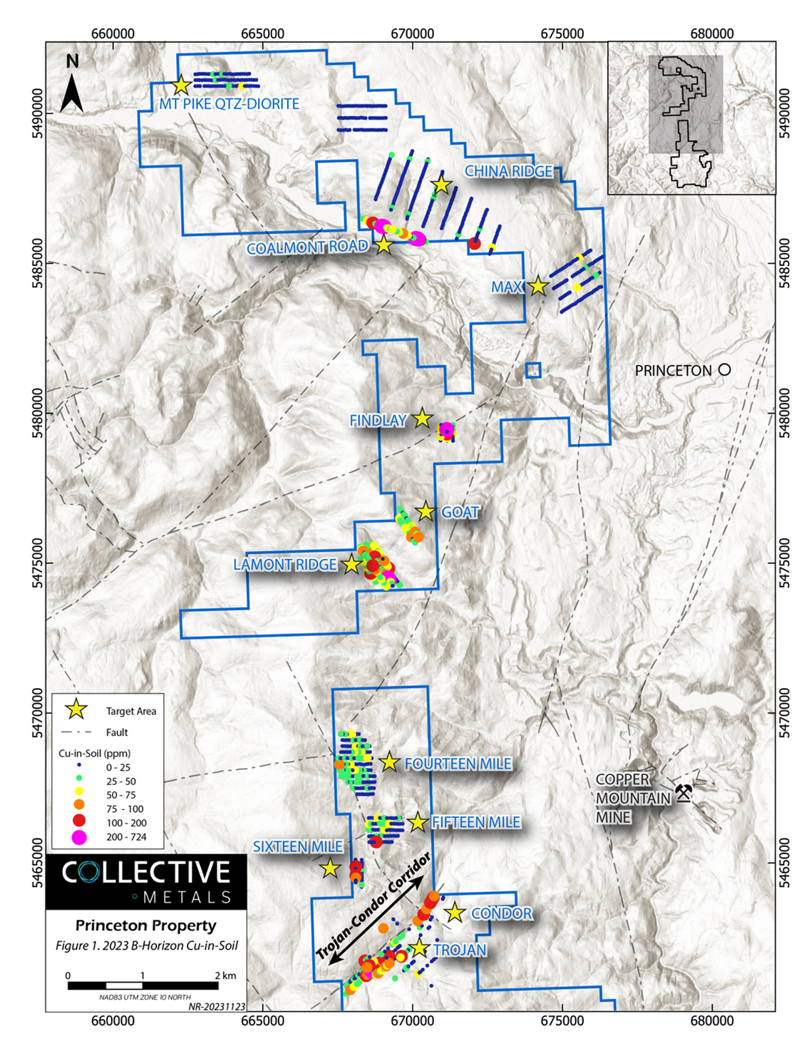
Collective Metals Inc. announced that it has obtained the final results of its two-phase soil geochemical survey (Program), which was finished in the summer of 2023 on the Princeton Project (Project). The soil samples were collected during Phase II of the program.
 Princeton Property Copper Soil Samples Image Credit: Collective Metals
The purpose of the program was to investigate two multi-element soil geochemical anomalies along the Trojan-Condor Corridor that were discovered during Phase I of the program.
In addition, a number of additional targets with favorable geology, geophysical signatures, and/or historical geochemistry were to be systematically tested. The Program detailed multiple more anomalies at the outboard target and extended two previously discovered anomalies (PA1 and PA2)
The Company intends to conduct more in-depth exploration in the Lamont Ridge, Coalmont Road, Findlay, Fourteen Mile, and Trojan-Condor target regions in 2024 because it believes that these areas have the potential to host multiple porphyry copper ± gold deposits.
The results of the 2023 soil program are very encouraging. In addition to further validating previously identified geophysical targets along the Trojan-Condor Corridor, we’ve defined robust geochemical anomalies at several other targets, most notably porphyry copper targets at Lamont Ridge and Coalmont Road. We plan to continue this strategy of systematically advancing exploration on multiple targets throughout the Property, which hosts several Triassic intrusions analogous to those associated with mineralization at Copper Mountain.
Chris Huggins, Chief Executive Officer, Collective Metals Inc.
The Copper Mountain Mine now mines copper-gold porphyry deposits, and the Trojan-Condor Corridor trends along the northwest edge of a significant aeromagnetic anomaly similar to this. The Copper Mountain Mine is located about 10 km to the northeast. A severe (>20 mV/V) chargeability anomaly across a large (roughly 1.5 x 3.3 km) section of the corridor was identified by a 2011 ground-based Induced Polarization (IP) survey.
The northeastern section of the Trojan-Condor Corridor, known as the "Condor" target, is where the strongest IP anomaly (>30 mV/V) is found over a large area (about 800 × 1000 m). A small copper, silver, gold, and tellurium soil geochemical anomaly was found during Phase I of the program over the Condor target along a single NE-trending line of primarily B-horizon soil samples.
Phase II soil samples on neighboring lines were primarily Ah-horizon soils; they produced anomalous lead, barium, gold, silver, zinc, tungsten, tellurium, and high molybdenum and selenium but not elevated copper.
A second multi-element copper-in-soil anomaly was found in Ah soils at the southwest extent of the survey grid in Phase I, slightly southwest of the Trojan Minfile showing, where rock samples have yielded up to 0.53% Cu.
Phase II B-horizon soil samples showed weak to significantly anomalous copper (up to 724 ppm) and associated gold, silver, molybdenum, lead, zinc, and tellurium over an area of around 400 x 1000 m. This anomaly was extended along three lines to the southwest. Geochemical anomalies in the soil related to copper, gold, and molybdenum were also found in Lamont Ridge, Coalmont Road, and other nearby sites.
While the previous operator's high-quality sieved sediment samples from 2011 produced highly anomalous copper (up to 504.5 ppm) in the Fourteen Mile area, the 2023 B-horizon soils did not produce elevated copper in the soil grids at the Fourteen Mile and Fifteen Mile targets, but they did return elevated pathfinder elements.
Lead, zinc, sulfur, and barium are among the multi-element geochemical anomalies found in three targets in the property's northern region: Max, China Ridge, and Mount Pike. These anomalies are more compatible with base-metal mineralization hosted by sulfides. In the upcoming weeks, a more thorough discussion of the soil results on these sites will be held, along with the interpretation of the geophysical and geological data.
Most of the Project has minimal bedrock exposure because of variable thicknesses of outwash deposits and glacial overburden. It is anticipated that the overburden thickness, the soil horizon sampled, and the development or disruption of the soil profile will all affect the soil geochemical reaction.
When interpreting soil geochemical data, it is important to take into account the resulting uncertainty in the relative magnitude and provenance of observed abnormalities. Phase II samples primarily contained B-horizon soil, whereas Phase I samples were primarily Ah-horizon dirt.
Most of the prior sampling on the land was high-quality, sieved sediment collected from streams and roadside exposures. Ultra-trace ICP-MS analysis and aqua regia digestion were used to analyze all soil samples (2011 and 2023) for examination.
Heberlein (2010) discovered that at Kwanika, where B-horizon soil samples are considered ineffectual because of tens of meters of glacial overburden, Ah-horizon soil samples (base of the organic layer) gave the most strong response for ore and pathfinder elements (Cu, Au, Ag, W, As, Sb, and Ca).
On the other hand, in Mt. Milligan, considerable surface disturbance from drilling and logging operations has altered the soil profile and nearly eliminated a geochemical anomaly from underlying mineralization, which is hidden beneath 5–25 m of till and glaciofluvial deposits.
Peak geochemical anomalies show how the thickness of the overburden determines the magnitude of soil geochemical anomalies, as they occur above the thinnest cover and are not always the strongest mineralization in both scenarios.
To get ready for its 2024 Exploration Program, the Company intends to keep assessing Project targets in the upcoming months using reprocessed geophysical data in conjunction with all available geochemical and geological data. In the upcoming months, the integration's results will be made public.