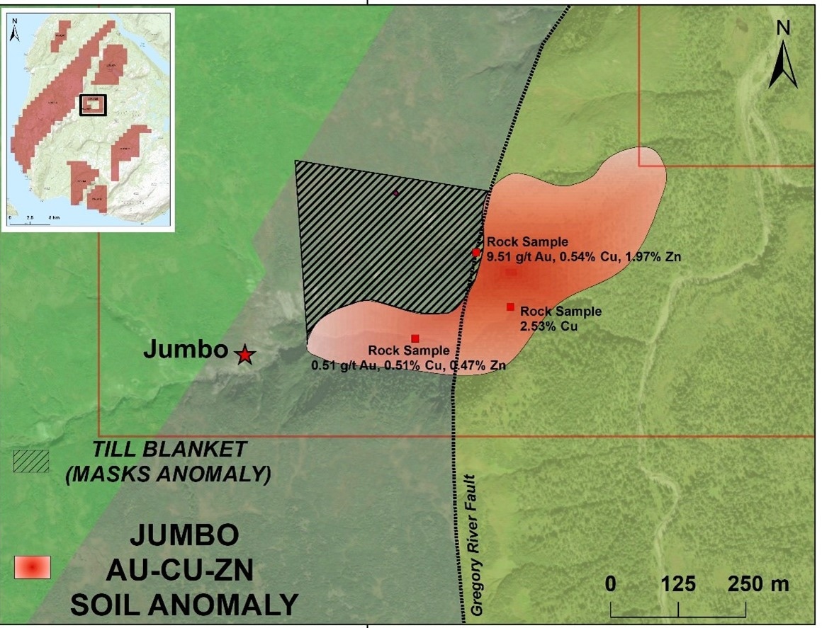
Vital Battery Metals Inc. announced the findings of the soil sampling and surficial geological study that were recently finished on the Sting project, which is situated in northwest Newfoundland.

Cu-Au-Zn Soil Anomaly on the Sting Project. Image Credit: Vital Battery Metals Inc.
Key Highlights
- A study on surficial geology has been concluded, revealing a correlation between anomalous values and colluvial material. This correlation suggests a nearby bedrock source.
- Highlighted results include 1.96 ppm gold, 0.27% copper and 0.42% zinc from soil.
- Along the Gregory River Fault, compellingly consecutive values of gold, copper, and zinc were found in the soil.
- Important multi-station soil results for zinc, copper, and gold in two zones along a ~2-km regional NE trend
- On trend with the York Harbor Copper Mine: The Gregory River Fault, a faulted contact between hypabyssal intrusive rocks and mafic marine volcanics, passes through the project’s center and the York Harbor Copper Mine to the south.
This expansive Cu-Au-Zn soil anomaly covering ground with no recorded mineralization highlights the prospectivity of the Project. More importantly, sampling and surficial mapping has revealed that the anomaly is likely sourced directly from underlying bedrock. When combined with recent rock sampling results, a compelling critical metal drill target is emerging.
Adrian Lamoureux, Chief Executive Officer and President, Vital Battery Metals Inc.
The coincident Cu-Au-Zn soil anomaly is caused by mafic rocks that are part of the Bay of Islands Complex, which is home to deposits of copper and copper/zinc, including the York Harbour Mine, a former producer 35 km to the south-southeast.
Rock sample results from the recently completed prospecting program have shown that the contact between these volcanic rocks and associated intrusive rocks, known as the Gregory River fault, within the Project has been shown to host copper, gold, and zinc mineralization.
The outcrop located on the southwestern flank of the soil anomaly yielded values of between 0.001 and 9.50 ppm gold, <1 to 48400 ppm copper, and 4 to 19700 ppm zinc.
Dr. Derek Turner, MSc, PhD, P.Geo. (B.C.), conducted a thorough surficial geology study over the Project's core claims on behalf of the Company. The study found that the soil anomaly strongly correlates with colluvial surficial material, suggesting that the anomaly is most likely derived from bedrock that is beneath the surface and has little gravitational or mechanical dispersion.
Till veneers (less than 1 m in depth) and till blankets (more than 1 m in depth) immediately west of the anomaly most likely conceal possible signs of bedrock mineralization.
Around 404 soil samples were gathered. The range of results was 4 to 2675 ppm Cu, 4 to 4164 ppm Zn, and less than 0.001 to 1.96 ppm Au.
When available, soil samples were taken from the B-horizon using long-handled rock hammers with spade blades. Around 200–400 g of material were put into brown kraft paper bags, which were then sealed with flagging tape. Each bag was given a sequential number that indicated the sampler’s location and was unique.
Samples were manually transported to the Grand Falls, Newfoundland prep facility of SGS Labs, where they were processed using code PRP104, which involves drying the samples to 60 °C and screening them through an 80-mesh screen.
The prepared material was then sent to SGS's main laboratory in Burnaby, British Columbia, where samples were subjected to analysis by ICP-MS using the method GE_ARM3V25. This involved a 2-acid digestion process that produced a 49-element suite.