Cypress Development has announced that it has completed a phase I drilling campaign at the Twenty-One silver-gold property, situated in west central Nevada.

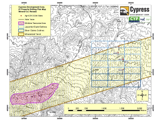
Twenty-One Silver- Gold Property Drill Hole Location Map
The company drilled 1700 m, totaling five holes during the reverse circulation drilling program, which was specifically designed to examine a 1-km wide alteration and local gold-lead-silver mineralization zone identified by the company during surface sampling program carried out at the adjacent Silver and Jasperiod claim blocks. The Twenty-One property is located in the Walker Lane metallogenic and structural province of West Nevada.
Cypress’ drill program was oriented to create the mineralized trend’s cross section. Sampling program was conducted on 10 ft intervals from the collar of the hole to depth. Large samples averaging around 8 kg were produced from the 10 ft sample intervals.
The company encountered high anomalous values of silver of up to 19 g/t in four holes out of five, along with high anomalous values of bismuth of up to 33 ppm. Bismuth mineralization indicates that the huge brecciation, alteration and silver mineralization area is associated with an intrusive igneous stock.
Cypress identified anomalous mineralization of bismuth and silver over down hole thicknesses of up to 270 ft in a silica brecciated and flooded volcaniclastic cap rock. Drilling also intersected hornblende porphyry dikes. The company is now studying the potential link of these dikes to the mineralized bismuth and silver.
Nevada-based ALS Chemex carried out assaying of the samples and did not find any significant assays in hole AJ-1.
Disclaimer: The views expressed here are those of the author expressed in their private capacity and do not necessarily represent the views of AZoM.com Limited T/A AZoNetwork the owner and operator of this website. This disclaimer forms part of the Terms and conditions of use of this website.