Jul 30 2020
Stelmine Canada Ltd has announced the restart of exploration activities at its Mercator property, situated at the Opinaca sedimentary basin’s eastern limit, next to the La Grande-Opinaca contact—regarded as the most gold-prospective region within the James Bay Territory.
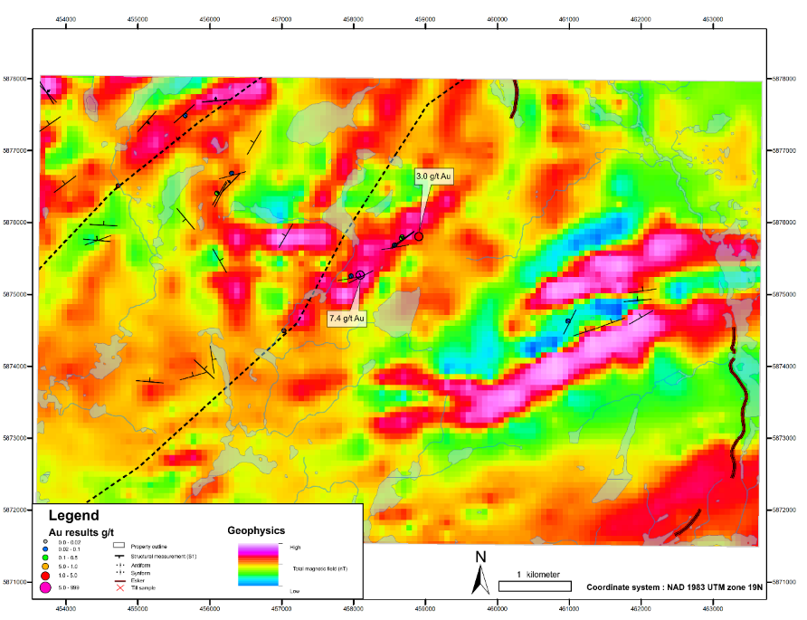
 Contour map of the Total Magnetic Intensity (TMI) of the Mercator property. The gold mineralization is associated with a positive anomaly related to the presence of an iron formation. Image Credit: Stelmine Canada Ltd.
La Grande-Opinaca’s eastern segment includes various gold mineralized zones related to iron formations.
As part of the exploration program, a NW/SE-oriented gold-bearing corridor extending to a minimum of 1 km will be analyzed in-depth. Grab sampling from this corridor returned gold values of 7.44 g/t Au and 3.0 g/t Au.
Stelmine hopes an extended exploration will help find new mineralized showings based on the strong deformation of all lithologies, the high arsenic content, and the exposures of iron formations.
We are eager to perform our first sustained work campaign on this property. Indeed, previous exploration completed in few days allowed the discovery of a second gold showing. We are currently at a phase where we can demonstrate the extension of the mineralized zone and develop a key sector to explore for gold due to its proximity to the Courcy gold property.
Isabelle Proulx, President and CEO, Stelmine Canada Ltd
Proulx added, “The occurrence of an important mineralization at Mercator would certainly increase the potential of the eastern La Grande-Opinaca contact that could indicate a new gold-rich sector seldom investigated until now.”
The mineralized zones found by Stelmine include oxidized and sulfurized (2% to10% sulfides, mostly pyrrhotite-pyrite) banded amphibolite-rich (grunerite) and garnet-bearing layers that could denote silicate-facies iron formations (that is, 0.44 g/t Au and 19 ppm As, 0.45 g/t Au et 87 ppm As, and 7.44 g/t Au et 1090 ppm As).
The Biblain showing discovered by the MERQ includes arsenopyrite veins, pyrite-pyrrhotite, and yielded Au concentrations from 0.84 to 3.0 g/t with high As concentrations (0.22%–0.96 %).
Such less studied showings relate to a positive Mag anomaly associated with the existence of iron formations and are located on a topographic high that reveals several outcrops.
The exploration program has been scheduled for 25 days and will be completed over the 2020 summer period. The three components included in the program are as follows:
- Structural and geological mapping of the gold-bearing corridor reaching beyond 1 km and including a search for mineralized extensions, as well as additional regional work on target zones determined during the 2018 campaign
- Additional analysis of high gold-prospective zones by means of closely spaced channel sampling and overburden stripping
- A regional till survey to enable heavy minerals extraction and analysis of sulfide minerals and gold grains