Dec 18 2020
Hemlo Explorers Inc., a Canadian-based mineral exploration company, reports that it has received exploration permits covering a large part of the claims on the North Limb Project and also the entire claims on the Pic Project from the Ontario Ministry of Energy, Northern Development and Mines (ENDM).
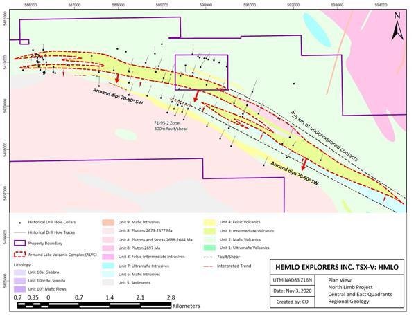
 Historical drill holes on the North Limb Project. Image Credit: Hemlo Explorers Inc.
Hemlo Explorers would like to commend the Biigtigong Nishnaabeg and the Netmizaaggamig Nishnaabeg First Nations for their input and cooperation in the permitting procedure.
The management has planned to initiate its exploration program on the North Limb in January 2021 from its recently built core-logging facility located in Manitouwadge and at the same time continue to improve the geologic models for the Pic project and the Hemlo West project to prepare for more exploration work.
We are very fortunate to be working in the Hemlo camp and consider our package of about 38,000 hectares of claims to contain some of the most prospective geology in the area. We are fully funded to complete the planned drilling campaign and look forward to getting started next month.
Mr Brian Howlett, CEO, Hemlo Explorers Inc.
North Limb Project
The management has also suggested drill testing for certain targets located on the North Limb Property. On these targets, various sections of the 8.2-km-long Armand Volcanic Complex (Armand Complex) trend will be tested based on many anomalies defined by drill intercepts, geophysical signatures, soil and rock assays.
According to Hemlo Explorers, the Armand Complex looks similar to the geological setting of the Moose Lake Volcanic Complex located at the prolific Hemlo Mine Complex. That complex has yielded more than 21 million oz ever since it commenced production back in 1985 and is anticipated to be in operation by at least 2030 (as stated by Barrick Gold Corporation).
Hemlo Explorers has designed a minimum initial 10,000-m drill program to test targets along the Armand Complex trend and also along the neighboring fault/shear trends.
Hemlo West Project
In May 2020, Hemlo Explorers had procured the Hemlo West Project as part of a transaction with O3 Mining Inc.—one of its key shareholders. The 6,000-hectare project, Hemlo West, contains a pair of converging deformation zones with anomalous occurrences of barite and gold and also other elements that are signature of the Hemlo Mine Complex.
The Hemlo West project also contains 7.5 km of the Heron Bay/Hemlo Deformation Zone, which is assumed to be crucial to the development of the original Hemlo Deposit. An in-depth review of previous exploration work is ongoing to detect favorable zones for further drill testing.
Hemlo Explorers has initiated the consultation procedure with the local First Nations with the aim of applying an exploration work permit for the Hemlo West project.
Pic Project
In early 2020, Hemlo Explorers performed an airborne detailed magnetic survey and ground geochem prospecting surveys across select regions of the 24,000-hectare Pic Project to further delineate the familiar gold anomalous regions located at Beggs and Porphyry Lakes.
A 3D model was designed at Wire Lake, and a review was carried out to establish the growth prospect along its 2.7-km intrusion-related gold shear trend. The review pinpointed a pair of parallel structural zones, where only limited exploration work was performed with a plunge/down-dip potential below the prevailing shallow drill intercepts of the Wire Lake trend.
On December 16th, 2020, the Ontario Government placed a Notice of Caution on lands located in the northern Lake Superior watershed. One or more First Nations had asserted aboriginal rights and title on these lands.
But this Notice of Caution does not have an impact on pre-existing mining claims, and the management believes that continued association with exploration activities and communities will not be affected.