 By Megan DaviesNov 7 2019
Canadian gold exploration company Loncor Resources Inc. has provided an update relating to exploration activities initiated by Barrick Gold Corporation via its subsidiary firm, Barrick Gold (Congo) SARL. Loncor Resources operates significant projects in the Democratic Republic of the Congo (DRC).
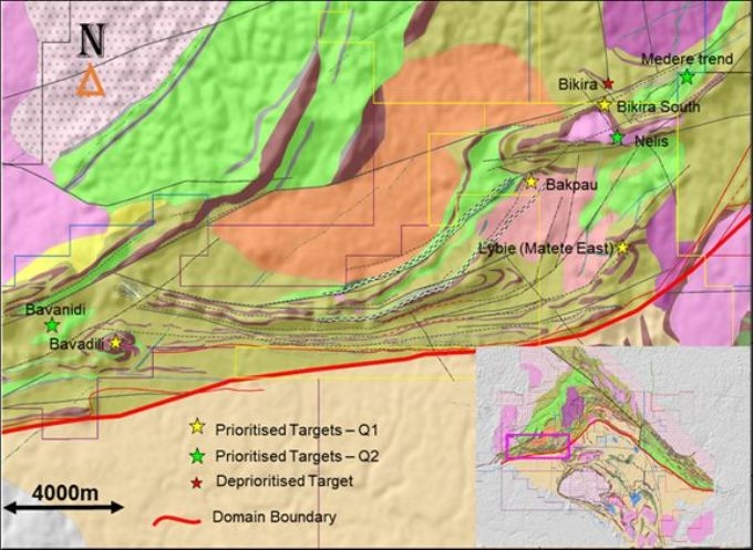
 Priority targets along the Imva Structure of the Ngayu Greenstone Belt. Image Credit: Loncor Resources Inc.
The exploration activities are being performed on Loncor Resources’ Ngayu Joint Venture Project located in northeastern DRC. The major Imva fold structure was the target of these recent exploration activities. Several drill targets in this structure have been advanced. Currently, drilling is scheduled to begin in the coming dry season.
The Mambati airstrip is set to open in September, and this development is anticipated to speed up the upcoming drilling program. The Ngayu Archaean Greenstone Belt is located 200 km southwest of the Kibali Gold Mine belonging to Barrick/AngloGoldAshanti.
During the most recent quarter, Barrick’s exploration activities at Ngayu have targeted four major regions situated along the Imva fold structure stretching to 30 km. These blocks are Bikira-Makasi, Lybie (Matete east)/Salisa, Bakpau, and Bavadili/Bavanidi. Additional trenching at the Bavadili block was performed to test the idea of a mineralized northwest-trending shear corridor that lies parallel to the inferred F2 axial plane.
Encouraging results were obtained, which included 24 m at 0.94 g/t gold (Au) and established the mineralized corridor with mineralization linked to brecciated cherty Banded Ironstone Formation (BIF) with weak hematite alteration and disseminated limonite, together with fine cubic boxworks (~ 5% pyrite) and sugary quartz veins.
The mineralization was found to occur along a ruggedly foliated northwest-southeast structure existing between basalt to the north and dolerite to the south.
Results have supported and validated the model of a +1.5 km prospective mineralized structure extending from Bavadili Hill to Bavanidi. Further trenching was performed at Bavadili Hill to check the continuity of the folded and mineralized cherty BIF, located 250 m southwest from the mineralized cherty BIF intersected in the BVTR0114A trench. This trenching yielded results of 24 m at 0.94 g/t Au.
Further work was carried out that involved a geological re-evaluation of the Bavadili Block, combining all data, including geophysical and geochemical data related to gold and multi-element soil, to gain a deeper insight into the regional model.
This recent understanding highlights over 6 km of numerous folded layers of anomalous BIF. These layers exhibit two sets of provincial F1 and F2 folds with the P1 axial plane, trending in northeast, revived by P2, trending in east-northeast, and creating the S-shape fold configuration.
This configuration is inferred to host the mineralized shoots inside the Bavadili Block. This understanding further indicates that the same BIF continues 12 km to the east of the Salisa/Lybie targets.
At the Lybie target, trench NZTR0006 provided encouraging results that established a continuous mineralized corridor of +1 km hosted inside the brecciated and volcaniclastic cherty BIF within an identified fold limb.
The trench NZTR0006 displayed a minimum of two continuous mineralized structures—the two northwestern structures are from colonial trenching that returned 20 m at 0.58g/t Au, while trench NZTR0006 returned 20 m at 0.54g/t Au.
At the Salisa target, rock sampling results assayed up to 3.75 g/t Au in volcaniclastic and also 3.05 g/t Au hosted in BIF. These matched with the soil source line trending in the northeast-southwest direction. A scout trenching program is also ongoing to better identify the mineralized system and limit the source and the potential of the higher grade rock samples.
At the Bakpau block, trenching has been concluded on north-south and northwest-southeast trending sections on broadly spaced trench lines. BKTR0005 and BKTR0006, the two trenches at 500 m northeast and southwest of trench BKTR0001 (70 m at 0.34g/t Au) returned 26 m at 0.35 g/t Au and 30 m at 0.12 g/t Au, respectively. Trenches like these have exposed and demonstrated the continuity of anomalous-grade, near-surface mineralization in the Bakpau East Zone over a 1.2-km strike length.
At Medere, the focus of the trenching undertaken on the +800-m long 80 ppb soil anomaly along the northeast trending hill was on establishing the controls on mineralization (alteration and structure) and also trends of mineralization along strike between the zones exposed in earlier trenches as well as artisanal pits.
During the most recent quarter, substantial gold results from the first trench across quartz stockwork style mineralization were obtained with a trench intersection of 48 m at 0.51g/t Au and remain exposed to the southeast. The present trenching was able to expose only the boundary of the soil anomaly because of the dense scree/talus cover on the hill slopes toward the southeast.
Apart from delineating drill targets along the Imva fold structure, drilling has been scheduled during the upcoming drill campaign at the Anguluku prospect region (including Bayinga, Golgotha, and Baberu) in the southwest side of the Ngayu greenstone.
The Ngayu greenstone contains a series of fine-grained metasediment, metabasalt, carbonaceous shale, and BIF trend approximately east-west and dip reasonably to south-southwest inside an antiformal structure. A preliminary 10-core hole (2490 m) drilling program has also been proposed to test 4500 m of a prospective strike.