Apr 1 2021
Midland Exploration Inc. announces that it has started a significant exploration program on its Samson gold project.
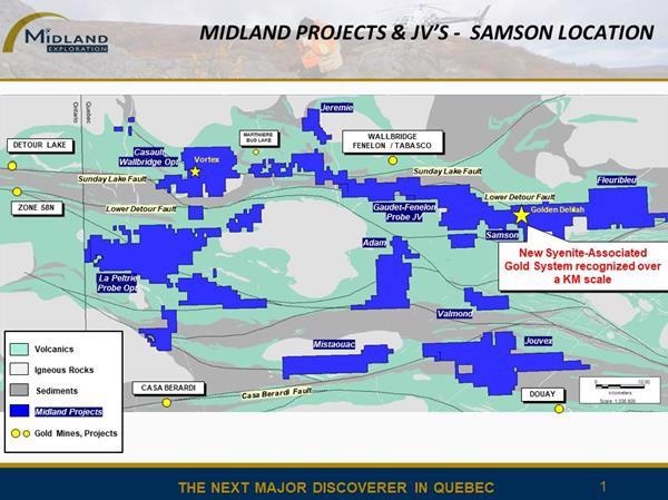
 Samson project location. Image Credit: Midland Exploration Inc.
The property is 100% owned by Midland and includes 280 claims in total, encompassing a surface area of around 156 km2. It is situated nearly 15 km to the southeast of the Tabasco and Fenelon deposits owned by Wallbridge Mining Company Ltd.
Highlights
- A new kilometer-scale syenite-associated gold system has been identified
- It hosts up to 23.0 g/t Au over 1.05 m and 99.1 g/t Au over 0.4 m at Golden Delilah
- Biogeochemical survey was completed recently and the results are being awaited
- 3D modeling is ongoing
- Geophysical survey (multi-separation IP) covering a total of 60 km is in progress
- Drilling campaign for 3,500 m has started
In 2020 summer, Midland identified a new 'syenite-associated disseminated gold' system on its Samson project. In Abitibi, this kind of gold system covers a number of significant deposits, such as Young-Davidson, Canadian Malartic and Holt-McDermott.
Two drilling campaigns encompassing 3,097 m in 12 drill holes were finished in 2020 and helped discover a new high-grade gold zone called Golden Delilah. This new discovery included a quartz-albite vein sectioned over a core length of 1.60 m and hosted in ultramafic intrusive rocks, which graded 0.17% Pb, 99.1 g/t Au, and 71.3 g/t Ag over 0.40 m from 106.45 to 106.85 m in the SAM-20-10 drill hole.
Then, the drill hole SAM-20-15, which was drilled about 350 m to the southeast of the Golden Delilah zone, found one more gold-bearing zone grading 23.0 g/t Au over 1.05 m from 317.10 to 318.15 m. This zone was part of a broader interval with anomalous arsenic and gold values over more than 20 m, from 314.95 to 337.25 m.
In 2020 winter, a biogeochemical survey (of black spruce bark) was just finalized and encompassed the whole grid that will also be utilized to carry out a multi-separation induced polarization (IP) survey on lines at a 200-m spacing, for a total of around 60 km.
Such surveys cover the southeast, east, and north extensions of the Golden Delilah discovery area.
Many structures are evident on the magnetic survey along the extensions of Golden Delilah and northward up to the regional Lower Detour Fault; these are considered as prospective subsidiary faults, quite similar to the fault at Zone 58N south of the Detour Lake mine.
Three-dimensional modeling is ongoing simultaneously, the aim of which is to observe and find alteration and mineralization vectors in close proximity to the Golden Delilah finding. This 3D model will consist of all available data such as drill hole data, as well as magnetic inversion and induced polarization models.
The newly launched drilling program is scheduled for at least 3,500 m and has been engineered to test the expansions of the most ideal high-grade gold zones found so far on Golden Delilah, together with other targets that might be found along the extensions of Golden Delilah and close to the Lower Detour Fault.