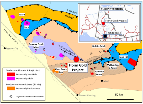
St. James Gold Corp. has released an analysis of the findings obtained by screening digital data from a Sentinel satellite image, which was chosen for its coverage across the project area at St. James’ Florin Project, which is located in Mayo District, Yukon Territory, Canada.
 Figure 1: Location of Florin Gold Project. Image Credit: St. James Gold Corp.
Highlights
- Sentinel satellite data interpretation uncovers a nearly 9 km2 (3.5 km by 2.5 km) WNW-ESE oval-shaped iron oxide signature that encloses the Florin Project’s 2.47M oz gold inferred resource.
- Filtering the data reveals an extreme iron oxide anomaly and two clay anomalies east of the oval signature near the Treadwell Adits, as well as a clay anomaly west of the oval signature, all of which could be apophyses of a kilometric scale intrusion beneath the inferred resource region.
- Additional modification anomalies have been identified outside the immediate vicinity of the Florin Inferred Resource, within the boundaries of the Florin claim group.
Sentinel is a beneficial first-pass way to map iron and clay components that can be used to determine gaps of iron oxide-rich gossan that may reflect residual iron content from sulfide mineralization and epithermal clay alteration that may portray feldspar collapse due to epithermal fluid flow in and around mineralized interferences.
The Sentinel data near the Florin Inferred Resource has been construed to demonstrate an oval signature for iron oxide with a long axis of 3.5 km and a WNW-ESE strike that roughly coincides with the strike of the Jethro fault.
A plausible explanation of this oval signature is that it is the result of a large, granitoid intrusion at a depth that contains the Florin Inferred Resource.
Numerous anomalies are highlighted at both ends of the oval signature along the Jethro fault:
- An iron oxide anomaly 700 m ESE of the Florin Inferred Resource, instantly to the southwest of the Treadwell Adits, where 2021 rock samples reverted 15.8 g/t Au and 11.15 g/t Au at the furthest ESE periphery of the oval signature;
- Two clay alteration anomalies 500 m and 1 km ESE of the Treadwell Adits, which span the east end of the Jethro Fault; and
- A diffuse clay modification anomaly 2.5 km WNW of the Florin Inferred Resource, instantaneously north of the trace of the Jethro fault, on the far WNW periphery of the oval signature.
If the oval signature represents a large intrusion at depth, these features could be interpreted as the surface expression of apophyses linked to a granitoid intrusive whose emplacement was governed by the Jethro Fault.
As a result, these discrepancies will be the focus of additional prospecting, mapping, and sampling during the upcoming field seasons. Other color anomalies have been defined within the Florin property boundaries and will be prospected in due time, in addition to these objectives.
These results point to exploration targets both in the close vicinity of and probably emplaced along with the same structure as the Florin Inferred Resource. They will be prospected and sampled to ascertain whether they constitute drill targets aimed at possibly increasing the inferred resource ounces at the Florin Gold Project. We are encouraged by the systematic exploration approach and at the district-scale potential of the Florin Gold Project keeping in mind that a very small percentage of these prospective targets have been drill tested.
George Drazenovic, CEO, St. James Gold
Dr. Stewart Jackson, P. Geo., senior technical advisor geologist and a qualified person as defined by National Instrument 43-101 (Standards of Disclosure for Minerals Projects), has vetted and evaluated the scientific and technical data presented in this press release as precise and has given his approval to this news release.