Nov 27 2018
Core Gold Inc. is happy to report that it has concluded a 1,927-meter drilling campaign at its fully owned Linderos property in Ecuador.
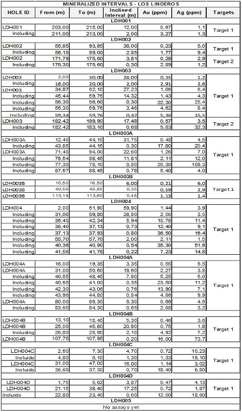
The results from this drilling campaign reveal the following select intervals:
- 7.80 m @ 5.25 g/t Au included within 19.60 m @ 2.27 g/t Au
- 5.94 m @ 10.78 g/t Au included within 28.80 m @ 2.56 g/t Au
These preliminary results offer evidence that the two key gold-bearing mineralized structures (target 1 and 2) revealed through Core Gold’s preliminary surface trenching program in 2017 extend at depth.
The gold mineralization so far identified is related to sulfide veins cutting intensely quartz-sericite-pyrite altered felsic igneous rocks. Mineralization is confined within an NW trending fault (shear zone) related brecciated structures totaling up to 25 m wide and are oxidized to a depth of approximately 30 m.
Late, gold-bearing sulfide veins are contained in discrete shoots within the NW trending fault zone. The controls on the localization of the high-grade gold mineralization have yet to be established.
Going forward, comprehensive mapping and structural analysis will result in an improved understanding of the controls of the gold mineralization and the creation of a predictive model.
Drilling so far has tested a comparatively small section of the 1 km by 150 m zone of outcropping gold mineralization beside and along strike from the discovery outcrop (21 m @18.51 g/t gold). The eastern half of the 1 km strike extent, highlighted by trench samples of 32 m @ 3.02 g/t Au and 4.40 m @ 11.11 g/t Au, is still to be drill tested and will be targeted in future drill campaigns.
So far, 11 exploration diamond drill holes from five sites have been performed all with azimuth ranging from 33° to 276° and six drill holes with an azimuth of 213°. Inclined depths range from 99 m to 280 m, with inclination angles from -45° to -75°. A Hydro-Core 2000 portable drill rig owned by Core Gold was used.
QA & QC procedures and protocols have been applied to ensure accuracy for this drilling campaign. Core samples have been sent to Inspectorate Lab in Peru, an international qualified laboratory. Details of the drill results are tabulated below. Note that true widths are not specified.

The Linderos Project
The Linderos project is an exploration property situated in the Macara County, Loja province, southern Ecuador. It is made up of four contiguous concessions totaling 14,317 hectares, situated approximately 45 km southwest of the Core Gold’s Dynasty Goldfield project. The Linderos project consists of gold-copper porphyry system style mineralization.
Within the Linderos project, the hydrothermal alterations zone spans an area of around 1.5 km2. The porphyry is emplaced in island arc Cretaceous volcanic rocks of the Celica Formation and it is structurally controlled by a shear zone with a northwest-southeast strike. This structure hosts economic porphyry related gold mineralization related with oxidized mesothermal-epithermal mineralized structures.
The porphyry system is developed by a primary intrusion of dioritic composition, which hosts late mineralized intrusive phases of tonalite, quartz-diorite, and rhyolite-dacite composition. The hydrothermal alterations zone is characterized by the occurrence of a potassic core surrounded by phyllic and propylitic alteration halos. Mineralization is largely related to copper and molybdenum seen as disseminated chalcopyrite and molybdenite in veinlets, essentially hosted in the quartz-diorite. Nearby, an oxidation zone has been detected with an occurrence of malachite and chrysocolla.